search
Sweden map
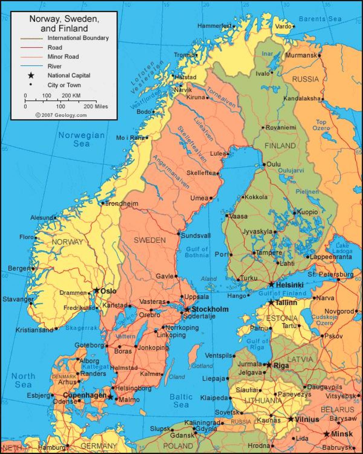
Sweden map location. Sweden map (Northern Europe - Europe) to print. Sweden map (Northern Europe - Europe) to download. Fourth in size among the countries of Europe, Sweden is the largest of the Scandinavian countries, with about 15% of its total area situated north of the Arctic Circle. Sweden is located on the Scandinavian Peninsula of northern Europe, between the countries of Norway and Finland. Extreme length north–south is 1,574 km (978 mi) and greatest breadth east–west is 499 km (310 mi). Sweden has a total area of 449,964 sq km (173,732 sq mi): land area, 410,934 sq km (158,663 sq mi); water area, 39,030 sq km (15,070 sq mi), including some 96,000 lakes as its shown in Sweden map.
Comparatively, the area occupied by Sweden is slightly larger than the state of California. Sweden is bounded on the north and north east by Finland, on the east by the Gulf of Bothnia, on the south east by the Baltic Sea, on the south west by the Öresund, the Kattegat, and the Skagarrak, and on the west by Norway, with a total boundary length of 5,423 km (3,370 mi), of which 3,218 km (2000 mi) is coastline as its mentioned in Sweden map. The two largest Swedish islands in the Baltic Sea are Gotland and Öland. Sweden's capital city, Stockholm, is located on the southeast Baltic Sea coast.
Sweden is a Northern European country located on the Scandinavian Peninsula. It is situated both in the Northern and Eastern hemispheres of the Earth. Sweden is bordered by 3 countries: by Finland in the east; by Norway in the north and west; by Denmark in the southwest (via a bridge-tunnel through Oresund Strait) as you can see in Sweden map. It is bounded by the Gulf of Bothnia and the Baltic Sea in the east and south; and by the Skagerrak and Kattegat straits in the southwest. Sweden shares its maritime borders with Germany, Denmark, Poland, Russia, Lithuania, Latvia and Estonia. Sweden has no outside territories or dependencies.
Sweden longest distances are as follow: 1,574 kilometers (978 miles) from north to south, 499 kilometers (310 miles) from east to west. Its land boundaries: 2,205 kilometers (1,370 miles) total boundary length; Finland 586 kilometers (364 miles); Norway 1,619 kilometers (1,006 miles) as its shown in Sweden map. The east and south coasts of Sweden lie on the Baltic Sea, which is linked to the North Sea by the narrow and shallow straits of the Kattegat and the Skagerrak. The Gulf of Bothnia, between Sweden and Finland, is the northern-most extension of the Baltic Sea. All of these bodies of water are considered to be extensions of the Atlantic Ocean.
The Arctic Circle is the imaginary line that circles the globe at about 66.5°N latitude as its mentioned in Sweden map. Areas north of the circle experience the phenomenon known as midnight sun, which is a period of time when the sun is visible for twenty-four hours or longer. During the summer solstice (usually on June 21 or 22) the sun is visible on the horizon at midnight from all points along the Arctic Circle. As you move further north, seasons of sunshine get longer, so that at the North Pole, there are six months of continuous sunshine, from the vernal equinox (usually on March 21 or 22) until the autumnal equinox (usually on September 21 or 22). The Arctic Circle also serves as a boundary between the North Temperate and the North Frigid climate zones. The extreme north of Norrland, north of the Arctic Circle, contains a region of wetland and tundra landscape, with large peat marshes covering 40 percent of the land.


